8 Days Trekking Kilimanjaro Via Lemosho Route
Overview
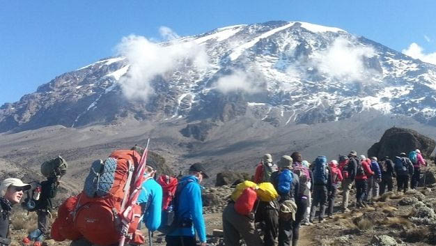
Lemosho route offers captivating scenic vistas, pristine wildlife, excellent acclimatization opportunities and the lowest traffic of other climbers, Lemosho is our most recommended route to reach the roof of Africa. 6, 7, and 8-day programs are available
The 8 day Lemosho variation is the ideal schedule for this route. On the 8 day Lemosho route, the trek from Barranco to Barafu is broken up into two days, allowing for a short day just prior to the summit attempt. This is important because summit day begins very early, around midnight, so climbers are sleep deprived going into the toughest day on the mountain. By having a short day beforehand, climbers can be better rested. The 8 day Lemosho route is highly recommended and used by most Kilimanjaro operators.
You will be picked up from the airport (Kilimanjaro International Airport) and be transferred to your hotel where you will rest and have a short pre-climb briefing and gear check.
Elevation: 7,800ft-9,500ft
Distance: 6 km
Hiking Time: 3-4 hours
We depart for Londorossi Gate, which takes about 4 hours, where you will complete entry formalities. Then drive to the Lemosho trailhead (another hour to reach the trailhead). Upon arrival at trailhead, we eat lunch, then commence through undisturbed forest which winds to the first camp site.
Elevation 9,500ft to 11,500ft;
Distance: 8 km;
Hiking Time 5-6 hours
We continue on the trail leading out of the forest and into a savannah of tall grasses, heather, and volcanic rock draped with lichen beards. As we ascend through the lush rolling hills and cross several streams, we reach the Shira Ridge before dropping gently down to Shira 1 camp. The view of Kibo from across the plateau is amazing.
Elevation: 11,500ft – 13,800 ft;
Distance: 14 km;
Hiking Time: 5-7 hours
We explore the Shira plateau for a full day. It is a gentle walk east toward Kibo’s glaciered peak, across the plateau which leads to Shira 2 camp on moorland meadows by a stream. Then we continue to Moir Hut, a little used site on the base of Lent Hills. A variety of walks are available on Lent Hills making this an excellent acclimatization opportunity. Shira is one of the highest plateaus on earth
Elevation: 13,800ft – 13,000ft;
Distance: 7 km;
Hiking Time: 4-6 hours
From the Shira Plateau, we continue to the east up a ridge, passing the junction towards the peak of Kibo. As we continue, our direction changes to the South East towards the Lava Tower, called the “Shark’s Tooth.” Shortly after the tower, we come to the second junction which brings us up to the Arrow Glacier at an altitude of 16,000ft. We now continue down to the Barranco Hut at an altitude of 13,000ft. Here we rest, enjoy dinner, and overnight. Although you end the day at the same elevation as when you started, this day is very important for acclimatization and will help your body prepare for summit day.
Elevation: 13,000ft-13,100ft;
Distance: 5km;
Hiking Time: 4-5 hours
After breakfast, we leave Barranco and continue on a steep ridge passing the Barranco Wall, to the Karanga Valley campsite. This is a short day meant for acclimatization
Elevation; 13,100ft -15,300ft;
Distance: 4 km;
Hiking Time: 4-5 hours
After breakfast, we leave Karanga and hit the junction which connects with the Mweka Trail. We continue up to the Barafu Hut. At this point, you have completed the South Circuit, which offers views of the summit from many different angles. Here we make camp, rest, enjoy dinner, and prepare for the summit day. The two peaks of Mawenzi and Kibo are to be seen from this position.
Elevation: 15,300ft -19,345ft;
Distance: 17 km descent;
Hiking Time: 13hours
Very early in the morning (midnight to 2am), we continue our way to the summit between the Rebmann and Ratzel glaciers. You head in a northwesterly direction and ascend through heavy scree towards Stella Point on the crater rim. This is the most mentally and physically challenging portion of the trek.
At Stella Point (18,600 ft), you will stop for a short rest and will be rewarded with the most magnificent sunrise you are ever likely to see (weather permitting). From Stella Point, you may encounter snow all the way on your 1-hour ascent to the summit. At Uhuru Peak, you have reached the highest point on Mount Kilimanjaro and the continent of Africa. Faster hikers will see the sunrise from the summit.
From the summit, we now make our descent continuing straight down to the Mweka Hut camp site, stopping at Barafu for lunch. You will want gaiters and trekking poles for the loose gravel going down. Mweka Camp is situated in the upper forest and mist or rain can be expected in the late afternoon. Later in the evening, we enjoy our last dinner on the mountain and a well-earned sleep.
Elevation: 10,000ft – 5,400ft;
Distance: 10 km;
Hiking Time: 3-4 hours
After breakfast, we continue the descent down to the Mweka Park Gate to receive your summit certificates. At lower elevations, it can be wet and muddy. Gaiters and trekking poles will help. Shorts and t-shirts will probably be plenty to wear (keep rain gear and warmer clothing handy).
Your driver will drive you back to the airport a couple of hours before your flight glad to have spent time with you. Thank you and we hope to see you again!
Inclusive
- All Park and Conservancy Fees
- 2 Nights’ accommodation (Bed & Breakfast Basis)in a Standard Hotel in Arusha or Moshi Town
- All meals while on the mountain in Full Board Basis
- Rescue & Evacuation Procedures from the Flying Doctors
- Camping Equipment’s like Four Seasonal Tents, Mattress, Tables & Chairs
- 2 Round way Airport Transfers
- Transport from the Hotel to the Mountain and Back
- Professional Crew of Guides, Cook and Porters.
Exclusive
- Tips and gratuities
- Expenses of Personal nature like Telephones, laundry, beverages etc.
- Meals and drinks at the hotel (Lunch & Dinner)
- Town tours and private excursions
- Hiring hiking gears
- Flight tickets and purchase of souvenir